| DESERT BIOME Deserts defined According to the Longman Dictionary of Environmental Science, a desert is:
That definition, based on climatic features, can be supplemented by one based on biology: a desert is
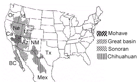
Examples from North America The North American deserts are highly accessible, well-characterised and well-researched so they serve as good examples of desert ecology. There are four major desert types of North America - the Great Basin Desert, Sonoran Desert, Chihuahuan Desert and Mojave Desert. They lie in a band down the western side of the USA, between the major mountain masses of the Rocky Mountains to the east and the Sierra Nevada to the west. Each of these deserts has a characteristic and distinctive type of vegetation. The approximate boundaries of these deserts are shown in the map below. Starting from the north:
Desert vegetation Scarcity of water is the overriding factor, giving rise to the characteristic desert vegetation. In wetter climes, plants compete for light so we see a high percentage of ground cover for light interception. This is expressed as leaf area index - the total area of photosynthetic leaf area divided by the area of ground surface. We also usually see a vertically structured community and a successional structure over time. For example, if a patch of woodland is cleared, we initially see a herb layer developing, then shrubs invade and eventually a climax forest community is re-established. But if a patch of desert is cleared then the same species will reappear, spaced out to exploit the available water. There is no successional pattern. Desert plant adaptations Desert plants can be grouped into three broad categories in terms of their adaptations to water shortage. Escapers, such as annuals, have seeds that lie dormant for several years. When they germinate the plants grow rapidly, then flower and set seed within a few weeks. Evaders, such as ocotillo, are perennials that drop their leaves or go into state of dormancy when water is deficient. Resisters, such as cacti and many desert shrubs, are adapted to minimise water loss (e.g. by having small leaves or photosynthetic stems) or have succulent tissues to store water. Many of these plants also have crassulacean acid metabolism (CAM) - a specific adaptation for conserving water. In CAM plants the stomata remain closed by day, to prevent water loss, but open at night to admit CO2. The CO2 is combined with the 3-carbon compound, phospho-enol-pyruvate, to form 4-carbon organic acids such as oxaloacetic acid and malic acid. Eseentially this is a method of storing CO2. Then, during the day (when the stomata are closed) CO2 is released from the organic acids and used for synthesis of sugars in the Calvin cycle. Desert plant communities Shown below are a few characteristic desert scenes, illustrating the diversity of desert communities.
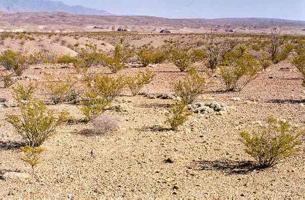
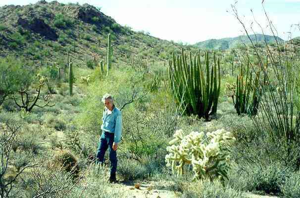
Creosote bush is among the commonest plants in lowland regions of the warmer North American deserts. Creosote bush thrives on well-drained areas of flat or sloping land - often with an underlying compacted soil layer of calcium (called caliche). Beneath the gravelly surface the soil consists of tightly packed sand and silt particles, with very little organic matter. These soils do not retain much water, so the plants are widely spaced, with extensive root systems to capture the available soil water. (Click here for more images and details). In stark contrast, the scene below shows a rich assemblage of larger cacti and leafy shrubs. Again, this is in the lower Sonoran region of the Arizona desert, but on a bajada - a sloping area where the soil is quite deep, with a mixture of particle sizes, ranging from boulders down to silt. These soils retain water within the soil profile and support a wide diversity of plants. Even so, all these plants are specially adapted to withstand periods of drought stress: the cacti have succulent tissues for water storage; the other larger shrubs such as palo verde (the small tree behind the standing figure) and ocotillo (the wand-like plant in the right foreground) have photosynthetic stems, not leaves, for most of the year; the low-growing, grey-green shrub (bursage) over most of the soil surface has hair-covered leaves that shrivel in periods of drought.
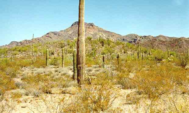
The transition between different types of vegetation can be very sharp if there is a change in slope or soil type, as seen in the scene below. Here the large cacti and shrubs of the slope of a bajada have been replaced by a mixture of bursage and creosote bush as the slope flattens and the soil has smaller particles with low water-retention (foreground). The large saguaro cactus in the forground is clearly unhealthy - possibly due to frost damage.
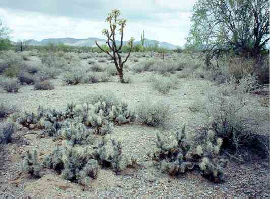
Another type of transition is seen in the image below, where the land at the foot of a bajada is flat and consists mainly of silt and sand. In this case the soil is calcareous and subject to intense evaporation of water from the surface, leading to a high surface salt content. An occasional large cholla cactus (e.g. the jumping cholla, in the centre) or mesquite tree (far right) can occur in such regions but the dominant plants are saltbush (the grey-green shrub, Atriplex polycarpa) and a low-lying cholla cactus - the devil club (foreground, Opuntia stanlyi and related species). These are among the few plants that thrive in salty, alkaline conditions. As the land starts to rise in the middle distance we see a green zone of palo verde and saguaro cactus.
Go to: |